Navigation
TrenchDotNav bakes a navigation mesh from a built map, so enemies and NPCs can find their way through it.
map.build()
var region := await TrenchDotNav.bake_region(map)
bake_region bakes on a worker thread, adds a NavigationRegion3D named navigation under the map and returns once
paths over it work. Pass a node that holds several maps to bake them all into one mesh. A rebuild frees the region, so
bake again after it.
What counts
The bake reads the map's collision, not its meshes, so whatever a player can bump into is what an agent walks around.
| In the map | In the navigation mesh |
|---|---|
World brushes, func_detail, terrain and prop collision |
Yes |
| Clip brushes | Yes, they block like walls |
| Illusionary brushes, triggers and physics props | No |
| Doors, buttons, platforms and trains | No, so a closed door does not seal its doorway |
Bodies in the navigation_ignore group |
No |
That means paths lead through closed doors, so an agent has to open a door it walks into.
Agent size
TrenchDotNav.profile(radius, height, max_climb, max_slope) gives you the settings for one agent size. The radius
keeps paths away from walls, the height rules out low ceilings, max_climb is the tallest step the agent walks up and
max_slope the steepest ramp. Sizes are in meters, the slope in degrees:
| Argument | Default |
|---|---|
radius |
0.3 |
height |
1.8 |
max_climb |
0.3 |
max_slope |
45 |
The mesh uses 0.1 m cells and snaps the sizes to them. Pass a profile as the second argument, for example for a wide, low creature:
var region := await TrenchDotNav.bake_region(map, TrenchDotNav.profile(0.5, 1.2))
(bake_region sets the cell size of the navigation map to the bake's, and other regions on that map have to share it.)
Caching
The first bake of a big map takes a few seconds. The result is cached in user://trenchdot_navigation, keyed by the
collision and the settings, so the next start with the same map loads it in a fraction of a second. Pass false as
the third argument to bake without the cache.
Checking a map
TrenchDotNav.bake(map) bakes on the calling thread and returns the NavigationMesh, handy for tools and tests.
TrenchDotNav.islands(nav) lists its unconnected parts as polygon indices, largest first.
A room that should be reachable but sits on an island of its own usually has a doorway blocked by something low, or a
step higher than max_climb. Wall tops and the floor inside thick walls show up as small islands too.
Warning
Godot stops a path search after 4096 polygons and returns the path so far, which looks like an
unreachable spot on a big map. TrenchDotNav.path(node, from, to) has no limit. For agents, set
path_search_max_polygons on the NavigationAgent3D to 0.
Seeing it in TrenchDot
You can see where an agent walks right in TrenchDot, without running the game.
-
Open the scene in Godot
Save the map inside the project, and open the project in the Godot editor with a scene whose
FuncGodotMapbuilds that map. -
Turn on the walkable area
Go to View > Walkable Area > Show Walkable Area. The agent size sits right below it, and the bottom line tells you how much is walkable and how many islands are cut off.
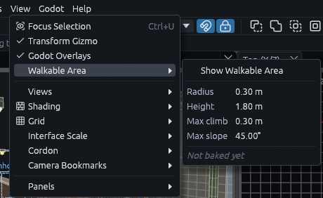
Godot bakes the scene over the live link and TrenchDot draws the result in the 3D and 2D views. (If it cannot bake, the status bar says why, for example that the map has to be saved into the project first.)
The colors mean:
| Color | Meaning |
|---|---|
| Bluish green | The biggest connected area, where most agents will be |
| Vermillion | Islands an agent on the green area cannot reach. Look for a step higher than Max climb, a gap narrower than twice the Radius or a slope steeper than Max slope |
The overlay bakes again a moment after each edit. Without live mode Godot builds the map as shown first, like Build in Godot.
Tip
Wall and roof tops show up as small vermillion islands. Look for vermillion floor next to green floor.
MCP
The MCP server lets agents and scripts drive the editor. They check a map with the walkability tool,
which returns the islands with their areas and bounds in map units.